by Geographers' A-z Map Co Ltd
on 12 October 2015
Style: single page illustrations
Pages: 80
Format: Soft cover

Goodreads
For lovers of maps! There are 40 maps to color in and be immersed in as you learn about the streets of London and regions of the UK

This post contains affiliate links you can use to purchase the product. If you buy a book using that link, I will receive a small commission. This does not affect the price that you pay. Your support is very much appreciated x
A-Z Maps Coloring Book Video Review
I hope you enjoyed the video review of the A- Z Maps Coloring Book.
A-Z Maps Coloring Book Review
I am a big fan of maps. I love them! I used to spend a lot of time in my career poring over maps, looking at topography, dimensions and boundaries. I love seeing building footprints and all the different shapes and sizes of streets. From a coloring point of view, I think that coloring maps is both enjoyable and educational. It is great to focus on streets and regions and see them come to life with your pencil. Coloring maps is also less intimidating if you are new to coloring. No need to think of skin and hair colors, shading and blending – you can just color in and have a good time. Map based coloring books, for this reason, are suitable for all ages and all skill levels.
Cover & Layout
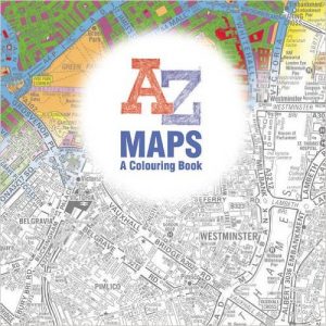
The cover of A-Z Maps Coloring Book features London suburbs part of which has been colored in. On the back cover there are two colored thumbnails from the book superimposed over a map of subrurbs of London featuring Hyde Park and Kensington (I used to live there!) On the inner cover there are 9 thumbnails from within the book, some of which have been colored. One of the colored images features a wash or blending effect that shows how you can color the images in different ways. On the back inside cover is a little information about Phyllis Pearsall MBE (1906-1996) the founder of Geographer’s A-Z Map Company and from all accounts a forward thinking and amazing woman.
The book measures 23.8cm x 23.8 cm (approximately 9.7in x 9.7in).
Ancillary Pages
A title page featuring an iconic London bus with a map superimposed on it commences the book. On the rear of the page is copyright infomraiton. This is the only page that you could use to test out your meidums.
Layout
The maps are presented on white single sided pages. THe paper is medium quality. Each map has been framed with a fine border. The maps have all been positioned well on the page and are away from the spine for ease of coloring.
Illustrations
The book contains 40 maps of different types. You will find street maps, contour line maps, map symbols and maps superimposed over a variety of shapes. Some of the maps are simplistic with very few lines and others are tightly packed with details.
The line art varies between the maps with some lines being a very faint grey (which may cause problems for those with visual impairment) and others being a rich black. The line weight also varies between maps ranging from fine to heavy depending on the map image. Many of the maps with tightly packed detail would be unsuitable for colorists that have arthritis in their hands, fingers or wrists (unless they used a color wash) as these small spaces could cause pain. Some of the maps will require a sharp pencil or fine liners for small details.
There are some illustrations that would benefit from some background pizzazz. Most of the images however do use the whole page.
At the foot of the image there is detail on where the map relates to.
A-Z Maps Coloring Book Image Gallery
Please click on the image for a detailed view.
[foogallery id=”3933″]Where to buy A-Z Maps Coloring Book
| Amazon US | Amazon UK | Amazon Canada | Book Depository |
Happy coloring x
Lea


Leave a Comment